
Thank you for supporting this site ❤️
Make a donation
Make a donation
Gear up for your next adventure:
As an Amazon Associate, this site earns from qualifying purchases at no extra cost to you.
Pico Chorrillos topographic map
Click on the map to display elevation.
Thank you for supporting this site ❤️
Make a donation
Make a donation
Gear up for your next adventure:
As an Amazon Associate, this site earns from qualifying purchases at no extra cost to you.
About this map
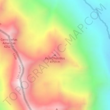
Name: Pico Chorrillos topographic map, elevation, terrain.
Average elevation: 12,438 ft
Minimum elevation: 10,833 ft
Maximum elevation: 14,068 ft
Thank you for supporting this site ❤️
Make a donation
Make a donation
Gear up for your next adventure:
As an Amazon Associate, this site earns from qualifying purchases at no extra cost to you.
Other topographic maps
Click on a map to view its topography, its elevation and its terrain.
Distrito Las Cuevas
Argentina > Mendoza > Distrito Las Cuevas
Es la localidad más elevada de la provincia (altitud 3557 m s. n. m.) y la situada más hacia el oeste.
Average elevation: 13,051 ft