
Cottonwood Island Park topographic map
Interactive map
Click on the map to display elevation.
About this map
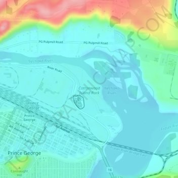
Name: Cottonwood Island Park topographic map, elevation, terrain.
Average elevation: 1,923 ft
Minimum elevation: 1,834 ft
Maximum elevation: 2,244 ft
Other topographic maps
Click on a map to view its topography, its elevation and its terrain.
Fraserview
Canada > British Columbia > Regional District of Fraser-Fort George > Prince George
Fraserview, Prince George, Regional District of Fraser-Fort George, British Columbia, Canada
Average elevation: 1,936 ft
Prince George
Canada > British Columbia > Regional District of Fraser-Fort George > Prince George
Prince George, Regional District of Fraser-Fort George, British Columbia, V2L 2K6, Canada
Average elevation: 2,323 ft