Geolocate

Trappe topographic map

Click on the map to display elevation.

About this map

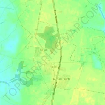
Name: Trappe topographic map, elevation, terrain.

Location: Trappe, Talbot County, Maryland, 21673, United States (38.64540 -76.07295 38.68114 -76.03231)

Average elevation: 43 ft

Minimum elevation: 3 ft

Maximum elevation: 69 ft

Talbot County trails, hiking, mountain biking, running and outdoor activities

Other topographic maps

Click on a map to view its topography, its elevation and its terrain.

Golton

United States > Maryland > Talbot County > Easton

Average elevation: 52 ft

Canterbury

United States > Maryland > Talbot County > Canterbury

Average elevation: 13 ft

Bozman

United States > Maryland > Talbot County > Bozman

Average elevation: 7 ft

Carters Plains

United States > Maryland > Talbot County > Easton

Average elevation: 49 ft

Gear up for your next adventure:

🪶Compact Camp Shovel - Folding shovel for campsite tasks
🔥Fast-Boil Camping Stoves - Efficient cooking systems for quick trail meals
🪶Camping Sleeping Pad - Comfortable sleeping pad for backpacking
🧼Biodegradable Camping Soap - Eco‑friendly soap for outdoor hygiene
🛌Ultralight Sleeping Bags - Compact down bags for cold nights in the wilderness

As an Amazon Associate, this site earns from qualifying purchases at no extra cost to you.