
Make a donation
Gear up for your next adventure:
As an Amazon Associate, this site earns from qualifying purchases at no extra cost to you.
Sichtigvor topographic map
Click on the map to display elevation.
Make a donation
Gear up for your next adventure:
As an Amazon Associate, this site earns from qualifying purchases at no extra cost to you.
Sichtigvor
Mülheim liegt auf einer Höhe von 241 bis 334 m über NN im mittleren Tal der Möhne am Nordrand des Sauerlandes zum sich nördlich daran anschließenden Haarstrang, hinter dem die Westfälische Bucht liegt.
Make a donation
Gear up for your next adventure:
As an Amazon Associate, this site earns from qualifying purchases at no extra cost to you.
About this map
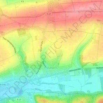
Name: Sichtigvor topographic map, elevation, terrain.
Average elevation: 932 ft
Minimum elevation: 771 ft
Maximum elevation: 1,086 ft
Make a donation
Gear up for your next adventure:
As an Amazon Associate, this site earns from qualifying purchases at no extra cost to you.
Other topographic maps
Click on a map to view its topography, its elevation and its terrain.
Oberhagen
Deutschland > Nordrhein-Westfalen > Kreis Soest > Warstein > Suttrop
Average elevation: 1,129 ft
Belecke
Deutschland > Nordrhein-Westfalen > Kreis Soest > Warstein
Belecke ist seit 1975 ein Ortsteil der Stadt Warstein im Kreis Soest in Nordrhein-Westfalen (Deutschland). Zum 1. Oktober 2020 hatte er 5386 Einwohner. Der Ort liegt zwischen dem Haarstrang im Norden und dem Sauerland im Süden an der Möhne. Das Zentrum des Orts befindet sich auf einer Höhe von 255 Metern…
Average elevation: 955 ft
Make a donation
Gear up for your next adventure:
As an Amazon Associate, this site earns from qualifying purchases at no extra cost to you.