Geolocate

Albaretto topographic map

Click on the map to display elevation.

About this map

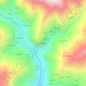
Name: Albaretto topographic map, elevation, terrain.

Location: Albaretto, Ingria, Torino, Piemonte, Italia (45.44594 7.56802 45.48594 7.60802)

Average elevation: 3,720 ft

Minimum elevation: 1,821 ft

Maximum elevation: 6,335 ft

Other topographic maps

Click on a map to view its topography, its elevation and its terrain.

Val Soana

Italia > Piemonte > Torino > Ingria

Average elevation: 4,777 ft

Gear up for your next adventure:

🧥Waterproof Jacket for Hiking - Breathable and rugged rain jacket for outdoor excursions
🌡️Portable Weather Meter - Track weather conditions on the trail
🧯Emergency Survival Kit - All‑in‑one survival essentials for the backcountry
🖼️Topo Map Wall Art - Decorative topographic prints of famous peaks and regions
🧴Hand Sanitizer - Keep hands clean while hiking

As an Amazon Associate, this site earns from qualifying purchases at no extra cost to you.