
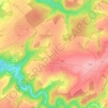
Zilshausen topographic map
Interactive map
Click on the map to display elevation.
About this map
Name: Zilshausen topographic map, elevation, terrain.
Average elevation: 1,073 ft
Minimum elevation: 689 ft
Maximum elevation: 1,289 ft
Other topographic maps
Click on a map to view its topography, its elevation and its terrain.
Fronhofen
Deutschland > Rheinland-Pfalz > Rhein-Hunsrück-Kreis
Fronhofen, Simmern-Rheinböllen, Rhein-Hunsrück-Kreis, Rheinland-Pfalz, Deutschland
Average elevation: 1,306 ft
Simmern/Hunsrück
Deutschland > Rheinland-Pfalz > Rhein-Hunsrück-Kreis
Simmern/Hunsrück, Simmern-Rheinböllen, Rhein-Hunsrück-Kreis, Rheinland-Pfalz, 55469, Deutschland
Average elevation: 1,243 ft
Sankt Goar
Deutschland > Rheinland-Pfalz > Rhein-Hunsrück-Kreis
Sankt Goar, Hunsrück-Mittelrhein, Rhein-Hunsrück-Kreis, Rheinland-Pfalz, Deutschland
Average elevation: 761 ft
Hahn
Deutschland > Rheinland-Pfalz > Rhein-Hunsrück-Kreis > Hahn
Hahn, Kirchberg (Hunsrück), Rhein-Hunsrück-Kreis, Rheinland-Pfalz, Deutschland
Average elevation: 1,516 ft
Boppard
Deutschland > Rheinland-Pfalz > Rhein-Hunsrück-Kreis > Boppard
Boppard, Rhein-Hunsrück-Kreis, Rheinland-Pfalz, 56154, Deutschland
Average elevation: 1,007 ft