
Sankt Goar topographic map
Interactive map
Click on the map to display elevation.
About this map
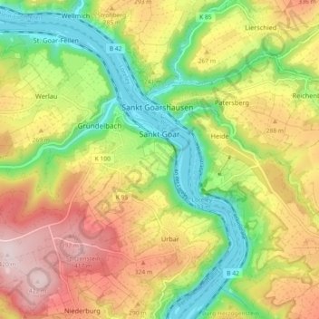
Name: Sankt Goar topographic map, elevation, terrain.
Average elevation: 761 ft
Minimum elevation: 220 ft
Maximum elevation: 1,388 ft
Die Stadt besteht aus der am Rhein liegenden Kernstadt Sankt Goar, den Höhenstadtteilen Biebernheim und Werlau, dem nördlich am Rhein gelegenen Stadtteil Fellen und dem südlich am Rhein gelegenen Stadtteil An der Loreley.
Other topographic maps
Click on a map to view its topography, its elevation and its terrain.
Fronhofen
Deutschland > Rheinland-Pfalz > Rhein-Hunsrück-Kreis
Fronhofen, Simmern-Rheinböllen, Rhein-Hunsrück-Kreis, Rheinland-Pfalz, Deutschland
Average elevation: 1,306 ft
Simmern/Hunsrück
Deutschland > Rheinland-Pfalz > Rhein-Hunsrück-Kreis
Simmern/Hunsrück, Simmern-Rheinböllen, Rhein-Hunsrück-Kreis, Rheinland-Pfalz, 55469, Deutschland
Average elevation: 1,243 ft
Zilshausen
Deutschland > Rheinland-Pfalz > Rhein-Hunsrück-Kreis
Zilshausen, Kastellaun, Rhein-Hunsrück-Kreis, Rheinland-Pfalz, Deutschland
Average elevation: 1,073 ft
Hahn
Deutschland > Rheinland-Pfalz > Rhein-Hunsrück-Kreis > Hahn
Hahn, Kirchberg (Hunsrück), Rhein-Hunsrück-Kreis, Rheinland-Pfalz, Deutschland
Average elevation: 1,516 ft
Boppard
Deutschland > Rheinland-Pfalz > Rhein-Hunsrück-Kreis > Boppard
Boppard, Rhein-Hunsrück-Kreis, Rheinland-Pfalz, 56154, Deutschland
Average elevation: 1,007 ft