
Make a donation
Gear up for your next adventure:
As an Amazon Associate, this site earns from qualifying purchases at no extra cost to you.
Pazos topographic map
Click on the map to display elevation.
Make a donation
Gear up for your next adventure:
As an Amazon Associate, this site earns from qualifying purchases at no extra cost to you.
About this map
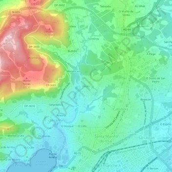
Name: Pazos topographic map, elevation, terrain.
Location: Pazos, Serantes, Ferrol, La Coruña, Galicia, 15405, España (43.48797 -8.25327 43.52797 -8.21327)
Average elevation: 243 ft
Minimum elevation: 0 ft
Maximum elevation: 846 ft
Make a donation
Gear up for your next adventure:
As an Amazon Associate, this site earns from qualifying purchases at no extra cost to you.
Other topographic maps
Click on a map to view its topography, its elevation and its terrain.
Serantes
España > Galicia > Ferrol > Ferrol
La ermita, construida en el siglo XVI, está situada en la ladera del monte del mismo nombre y desde su atrio, a 175 m de altitud, se contempla una magnífica vista panorámica de la comarca ferrolana, con el valle de Serantes en primer término y al fondo la ciudad de Ferrol. Esta ermita tiene una extraña y…
Average elevation: 279 ft