
Make a donation
Gear up for your next adventure:
As an Amazon Associate, this site earns from qualifying purchases at no extra cost to you.
Silver Springs topographic map
Click on the map to display elevation.
Make a donation
Gear up for your next adventure:
As an Amazon Associate, this site earns from qualifying purchases at no extra cost to you.
About this map
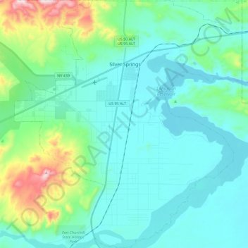
Name: Silver Springs topographic map, elevation, terrain.
Location: Silver Springs, Lyon County, Nevada, 89429, United States (39.28661 -119.32496 39.46040 -119.11810)
Average elevation: 4,482 ft
Minimum elevation: 4,121 ft
Maximum elevation: 6,115 ft
Lyon County trails, hiking, mountain biking, running and outdoor activities
Make a donation
Gear up for your next adventure:
As an Amazon Associate, this site earns from qualifying purchases at no extra cost to you.
Other topographic maps
Click on a map to view its topography, its elevation and its terrain.
Mason Valley Swimming Pool Park
United States > Nevada > Lyon County > Yerington
Average elevation: 4,383 ft