
Thank you for supporting this site ❤️
Make a donation
Make a donation
Gear up for your next adventure:
As an Amazon Associate, this site earns from qualifying purchases at no extra cost to you.
Do`ltaly topographic map
Click on the map to display elevation.
Thank you for supporting this site ❤️
Make a donation
Make a donation
Gear up for your next adventure:
As an Amazon Associate, this site earns from qualifying purchases at no extra cost to you.
About this map
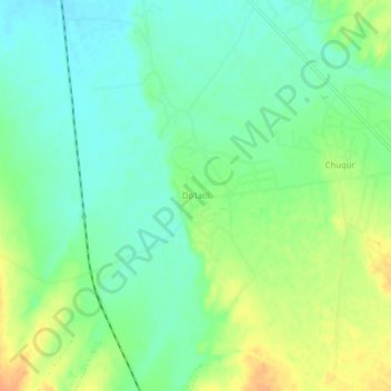
Name: Do`ltaly topographic map, elevation, terrain.
Location: Do`ltaly, Qashqadaryo Region, 180000, Uzbekistan (38.60583 66.07528 38.64583 66.11528)
Average elevation: 1,552 ft
Minimum elevation: 1,503 ft
Maximum elevation: 1,621 ft
Thank you for supporting this site ❤️
Make a donation
Make a donation
Gear up for your next adventure:
As an Amazon Associate, this site earns from qualifying purchases at no extra cost to you.
Other topographic maps
Click on a map to view its topography, its elevation and its terrain.