Geolocate

Neah Bay topographic map

Click on the map to display elevation.

About this map

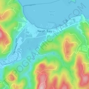
Name: Neah Bay topographic map, elevation, terrain.

Location: Neah Bay, Clallam County, Washington, 98357, United States (48.33916 -124.64734 48.37919 -124.58623)

Average elevation: 236 ft

Minimum elevation: -13 ft

Maximum elevation: 876 ft

Clallam County trails, hiking, mountain biking, running and outdoor activities

Other topographic maps

Click on a map to view its topography, its elevation and its terrain.

Joyce

United States > Washington > Clallam County

Average elevation: 463 ft

Joyce

United States > Washington > Clallam County

Average elevation: 404 ft

Bogachiel Peak

United States > Washington > Clallam County

Average elevation: 4,446 ft

Moose Lake

United States > Washington > Clallam County

Average elevation: 5,692 ft

Sekiu

United States > Washington > Clallam County

Sekiu Airport is located a mile west of Sekiu and offers a 2,997-foot (913 m) lighted runway with a visual approach indicator, at an elevation of 350 feet (110 m).

Average elevation: 194 ft

Dungeness

United States > Washington > Clallam County

Average elevation: 16 ft

Hurricane Ridge

United States > Washington > Clallam County

Average elevation: 4,367 ft

Jamestown

United States > Washington > Clallam County

Average elevation: 23 ft

Agnew

United States > Washington > Clallam County

Average elevation: 177 ft

Crane

United States > Washington > Clallam County

Average elevation: 200 ft

Maple Grove

United States > Washington > Clallam County

Average elevation: 1,263 ft

Piedmont

United States > Washington > Clallam County

Average elevation: 1,129 ft

Pysht

United States > Washington > Clallam County

Average elevation: 171 ft

Rena

United States > Washington > Clallam County

Average elevation: 226 ft

Sappho

United States > Washington > Clallam County

Average elevation: 564 ft

Mora

United States > Washington > Clallam County

Average elevation: 95 ft

Happy Valley

United States > Washington > Clallam County

Average elevation: 778 ft

Clallam Bay

United States > Washington > Clallam County

Average elevation: 128 ft

Baldy

United States > Washington > Clallam County

Average elevation: 5,650 ft

Quillayute

United States > Washington > Clallam County > Quillayute

Average elevation: 151 ft

Eagle Point

United States > Washington > Clallam County

Average elevation: 5,033 ft

Gear up for your next adventure:

🌲Outdoor Survival Books - Best books on survival skills
🏫Relief Map Kits - Hands-on tools for teaching landforms and elevation
🧭Pro Hiking Compasses - High-accuracy liquid-filled compasses for topographic orientation
❄️Traction Cleats - Prevent slips on icy trails during winter hikes
🎒Hydration Pack - Hands‑free water reservoir for long hikes

As an Amazon Associate, this site earns from qualifying purchases at no extra cost to you.