
Make a donation
Gear up for your next adventure:
As an Amazon Associate, this site earns from qualifying purchases at no extra cost to you.
Selayang topographic map
Click on the map to display elevation.
Make a donation
Gear up for your next adventure:
As an Amazon Associate, this site earns from qualifying purchases at no extra cost to you.
Selayang
Given its varied topography pattern and close proximity to the Titiwangsa Mountains (Banjaran Titiwangsa), Selayang is a mix of urban and countryside sceneries. Its premier natural attraction, which is well-known across the country, is the Forest Research Institute Malaysia (FRIM), also known as FRIM Kepong. As a leading institute in tropical forestry research, it administers the sustainable management of the forest for the purpose of preservation and research. The institute dates back to 1926. This forest reserve area covers part of Kepong, Selayang (Bukit Lagong) and Rawang (Templer). Home for numerous species of flora and fauna. FRIM also functions as educational and recreational destination well equipped with infrastructures such as laboratory, information centre, sport facilities, a waterfall, river, trekking route, canopy walk, etc. The species are highly protected and visitors could see tags attached to trees displaying the names as well as quite rare animals on ground.
Make a donation
Gear up for your next adventure:
As an Amazon Associate, this site earns from qualifying purchases at no extra cost to you.
About this map
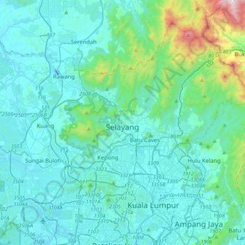
Name: Selayang topographic map, elevation, terrain.
Location: Selayang, Selangor, 68100, Malaysia (3.09903 101.49459 3.41903 101.81459)
Average elevation: 659 ft
Minimum elevation: -164 ft
Maximum elevation: 5,505 ft
Make a donation
Gear up for your next adventure:
As an Amazon Associate, this site earns from qualifying purchases at no extra cost to you.