
Lago Mascardi topographic map
Interactive map
Click on the map to display elevation.
About this map
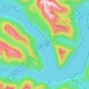
Name: Lago Mascardi topographic map, elevation, terrain.
Average elevation: 3,576 ft
Minimum elevation: 2,612 ft
Maximum elevation: 6,686 ft
Other topographic maps
Click on a map to view its topography, its elevation and its terrain.
Municipio de Viedma
Municipio de Viedma, Departamento Adolfo Alsina, Río Negro, Argentina
Average elevation: 62 ft
Bajada de Echandi
Argentina > Río Negro > Municipio de Viedma
Bajada de Echandi, Municipio de Viedma, Departamento Adolfo Alsina, Río Negro, Argentina, Echandi
Average elevation: 92 ft
Cerro San Francisco
Cerro San Francisco, Departamento Conesa, Río Negro, Argentina
Average elevation: 272 ft