Geolocate

Ruaka topographic map

Click on the map to display elevation.

About this map
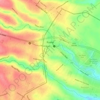
Name: Ruaka topographic map, elevation, terrain.

Location: Ruaka, Kiambaa, Kiambu, Kenya (-1.21379 36.76671 -1.20169 36.79327)

Average elevation: 5,751 ft

Minimum elevation: 5,571 ft

Maximum elevation: 5,873 ft

Other topographic maps

Click on a map to view its topography, its elevation and its terrain.

karuri

Kenya > Kiambu > Kiambaa > Karuri ward

Average elevation: 6,119 ft

Ndenderu ward

Kenya > Kiambu > Kiambaa

Average elevation: 6,083 ft

Cianda ward

Kenya > Kiambu > Kiambaa

Average elevation: 6,191 ft

Gear up for your next adventure:

🌄Hiking Binoculars - Compact binoculars for scenic views and trail spotting
📖Nature Tracking Books - Learn to track wildlife and terrain
🧭Outdoor Navigation Book - Learn advanced navigation skills
🪑Portable Camp Table - Compact table for campsite meals
📶Satellite Messenger - Communication device off‑grid

As an Amazon Associate, this site earns from qualifying purchases at no extra cost to you.