
Donauwörth topographic map
Interactive map
Click on the map to display elevation.
About this map
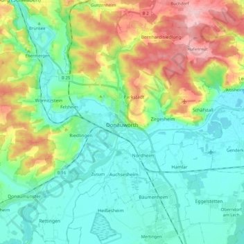
Name: Donauwörth topographic map, elevation, terrain.
Location: Donauwörth, Landkreis Donau-Ries, Bavaria, 86609, Germany (48.67555 10.66884 48.76341 10.86788)
Average elevation: 1,453 ft
Minimum elevation: 1,293 ft
Maximum elevation: 1,841 ft
Other topographic maps
Click on a map to view its topography, its elevation and its terrain.
Ries
Germany > Bavaria > Landkreis Donau-Ries
Ries, Landkreis Donau-Ries, Bavaria, Germany
Average elevation: 1,588 ft
Harburg (Schwaben)
Germany > Bavaria > Landkreis Donau-Ries
Harburg (Schwaben), Landkreis Donau-Ries, Bavaria, 86655, Germany
Average elevation: 1,552 ft
Rain
Germany > Bavaria > Landkreis Donau-Ries
Rain, Rain (Schwaben), Landkreis Donau-Ries, Bavaria, 86641, Germany
Average elevation: 1,358 ft
Hühnerberg
Germany > Bavaria > Landkreis Donau-Ries > Harburg (Schwaben)
Hühnerberg, Harburg (Schwaben), Landkreis Donau-Ries, Bavaria, 86655, Germany
Average elevation: 1,430 ft
Nördlingen
Germany > Bavaria > Landkreis Donau-Ries
Nördlingen, Landkreis Donau-Ries, Bavaria, Germany
Average elevation: 1,486 ft