Geolocate

Ries topographic map

Interactive map

Click on the map to display elevation.

About this map

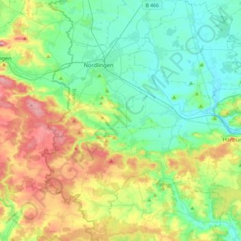
Name: Ries topographic map, elevation, terrain.

Location: Ries, Landkreis Donau-Ries, Bavaria, Germany (48.69473 10.41207 48.90927 10.68433)

Average elevation: 1,588 ft

Minimum elevation: 1,325 ft

Maximum elevation: 2,205 ft

Other topographic maps

Click on a map to view its topography, its elevation and its terrain.

Harburg (Schwaben)

Germany > Bavaria > Landkreis Donau-Ries

Harburg (Schwaben), Landkreis Donau-Ries, Bavaria, 86655, Germany

Average elevation: 1,552 ft

Rain

Germany > Bavaria > Landkreis Donau-Ries

Rain, Rain (Schwaben), Landkreis Donau-Ries, Bavaria, 86641, Germany

Average elevation: 1,358 ft

Hühnerberg

Germany > Bavaria > Landkreis Donau-Ries > Harburg (Schwaben)

Hühnerberg, Harburg (Schwaben), Landkreis Donau-Ries, Bavaria, 86655, Germany

Average elevation: 1,430 ft

Rain

Germany > Bavaria > Landkreis Donau-Ries > Rain > Rain

Rain, Rain (Schwaben), Landkreis Donau-Ries, Bavaria, 86641, Germany

Average elevation: 1,329 ft

Nördlingen

Germany > Bavaria > Landkreis Donau-Ries

Nördlingen, Landkreis Donau-Ries, Bavaria, Germany

Average elevation: 1,486 ft

Donauwörth

Germany > Bavaria > Landkreis Donau-Ries

Donauwörth, Landkreis Donau-Ries, Bavaria, 86609, Germany

Average elevation: 1,453 ft