
Pigeon River Country State Forest topographic map
Interactive map
Click on the map to display elevation.
About this map
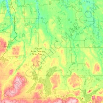
Name: Pigeon River Country State Forest topographic map, elevation, terrain.
Average elevation: 948 ft
Minimum elevation: 669 ft
Maximum elevation: 1,424 ft
Other topographic maps
Click on a map to view its topography, its elevation and its terrain.
Vanderbilt
United States > Michigan > Otsego County
Vanderbilt, Corwith Township, Otsego County, Michigan, 49795, United States
Average elevation: 1,096 ft
Chester Township
United States > Michigan > Otsego County
Chester Township, Otsego County, Michigan, United States
Average elevation: 1,286 ft
Charlton Township
United States > Michigan > Otsego County
Charlton Township, Otsego County, Michigan, 49751, United States
Average elevation: 1,207 ft
Apache Lake
United States > Michigan > Otsego County
Apache Lake, Bagley Township, Otsego County, Michigan, United States
Average elevation: 1,286 ft
Gaylord
United States > Michigan > Otsego County > Gaylord
Gaylord, Otsego County, Michigan, United States
Average elevation: 1,316 ft