Geolocate

Chester Township topographic map

Click on the map to display elevation.

About this map

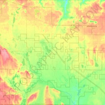
Name: Chester Township topographic map, elevation, terrain.

Location: Chester Township, Otsego County, Michigan, United States (44.85690 -84.60674 45.02757 -84.48612)

Average elevation: 1,286 ft

Minimum elevation: 1,132 ft

Maximum elevation: 1,447 ft

Other topographic maps

Click on a map to view its topography, its elevation and its terrain.

Waters

United States > Michigan > Otsego County

Average elevation: 1,358 ft

Elmira

United States > Michigan > Otsego County > Elmira Township

Average elevation: 1,276 ft

Apache Lake

United States > Michigan > Otsego County

Average elevation: 1,286 ft

Gear up for your next adventure:

🥾Men's Hiking Boots - Durable, waterproof footwear for rugged terrain and steep inclines
🏫Relief Map Kits - Hands-on tools for teaching landforms and elevation
🧭Orienteering Set - Complete compass and map reading kit
🥇GPS Hiking Watch - Multi‑sport GPS watch with navigation and trail tracking
🕶️Glacier Sunglasses - Side shields to protect eyes from high-altitude snow glare

As an Amazon Associate, this site earns from qualifying purchases at no extra cost to you.