
Thank you for supporting this site ❤️
Make a donation
Make a donation
Gear up for your next adventure:
As an Amazon Associate, this site earns from qualifying purchases at no extra cost to you.
Zingem topographic map
Click on the map to display elevation.
Thank you for supporting this site ❤️
Make a donation
Make a donation
Gear up for your next adventure:
As an Amazon Associate, this site earns from qualifying purchases at no extra cost to you.
About this map
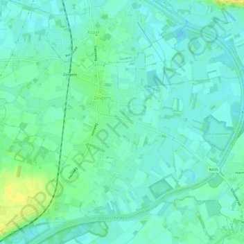
Name: Zingem topographic map, elevation, terrain.
Location: Zingem, Kruisem, Oudenaarde, Oost-Vlaanderen, Vlaanderen, België (50.88627 3.63026 50.91450 3.68666)
Average elevation: 36 ft
Minimum elevation: 10 ft
Maximum elevation: 89 ft
Thank you for supporting this site ❤️
Make a donation
Make a donation
Gear up for your next adventure:
As an Amazon Associate, this site earns from qualifying purchases at no extra cost to you.