
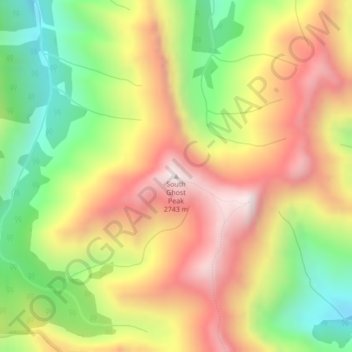
South Ghost Peak topographic map
Interactive map
Click on the map to display elevation.
About this map
Name: South Ghost Peak topographic map, elevation, terrain.
Average elevation: 7,349 ft
Minimum elevation: 6,053 ft
Maximum elevation: 8,619 ft
Other topographic maps
Click on a map to view its topography, its elevation and its terrain.
Kananaskis
Canada > Alberta > Municipal District of Bighorn > Kananaskis
Kananaskis, Municipal District of Bighorn, Alberta, T0L 2C0, Canada
Average elevation: 4,678 ft
Gap Lake
Canada > Alberta > Municipal District of Bighorn
Gap Lake, Municipal District of Bighorn, Alberta, Canada
Average elevation: 4,672 ft
Waiparous
Canada > Alberta > Municipal District of Bighorn
Waiparous, Municipal District of Bighorn, Alberta, Canada
Average elevation: 4,390 ft
Exshaw
Canada > Alberta > Municipal District of Bighorn
Exshaw, Municipal District of Bighorn, Alberta, T0L 2C0, Canada
Average elevation: 4,659 ft
Dormer Mountain
Canada > Alberta > Municipal District of Bighorn
Dormer Mountain, Municipal District of Bighorn, Alberta, Canada
Average elevation: 7,359 ft