Geolocate

Jeneffe topographic map

Click on the map to display elevation.

About this map

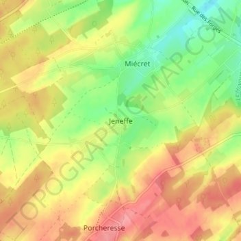
Name: Jeneffe topographic map, elevation, terrain.

Location: Jeneffe, Dinant, Namur, Wallonie, 5370, Belgique (50.33633 5.22520 50.37633 5.26520)

Average elevation: 978 ft

Minimum elevation: 833 ft

Maximum elevation: 1,109 ft

Other topographic maps

Click on a map to view its topography, its elevation and its terrain.

5370

Belgique > Namur > Dinant > Jeneffe

Average elevation: 928 ft

Gear up for your next adventure:

🧥Waterproof Jacket for Hiking - Breathable and rugged rain jacket for outdoor excursions
📦Dry Bags Set - Waterproof storage for electronics and clothes
🧣Hiking Neck Gaiter - Multi‑use neck protection for outdoor weather
🔥Plasma Lighters - Windproof lighters that work in any weather condition
🪑Ultralight Camp Chairs - Portable seating for resting after a long day of mapping

As an Amazon Associate, this site earns from qualifying purchases at no extra cost to you.