
Make a donation
Gear up for your next adventure:
As an Amazon Associate, this site earns from qualifying purchases at no extra cost to you.
Gundagai topographic map
Click on the map to display elevation.
Make a donation
Gear up for your next adventure:
As an Amazon Associate, this site earns from qualifying purchases at no extra cost to you.
Gundagai
Gundagai is an inland town with an elevation of 232 metres (761 ft). Almost all of the shire is located in the South West Slopes bio-region and is part of the Riverina agricultural region. The eastern part of the shire is considered part of the South Eastern Highlands bioregion.
Make a donation
Gear up for your next adventure:
As an Amazon Associate, this site earns from qualifying purchases at no extra cost to you.
About this map
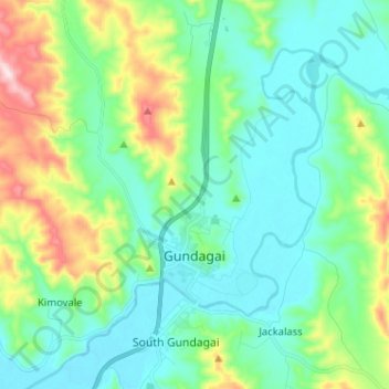
Name: Gundagai topographic map, elevation, terrain.
Average elevation: 1,014 ft
Minimum elevation: 682 ft
Maximum elevation: 2,041 ft
Make a donation
Gear up for your next adventure:
As an Amazon Associate, this site earns from qualifying purchases at no extra cost to you.
Other topographic maps
Click on a map to view its topography, its elevation and its terrain.
The Three Sisters
Australia > New South Wales > Cootamundra-Gundagai Regional Council > Cootamundra
Average elevation: 1,322 ft
Kangaroo Mount
Australia > New South Wales > Cootamundra-Gundagai Regional Council > Gobarralong
Average elevation: 837 ft
Burrinjuck Dam
Australia > New South Wales > Cootamundra-Gundagai Regional Council > Wee Jasper > Adjungbilly
Average elevation: 1,798 ft