Geolocate

Overton topographic map

Click on the map to display elevation.

About this map

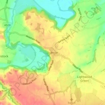
Name: Overton topographic map, elevation, terrain.

Location: Overton, Wrexham, Wales, LL13 0ED, United Kingdom (52.94984 -2.95447 52.98984 -2.91447)

Average elevation: 174 ft

Minimum elevation: 46 ft

Maximum elevation: 312 ft

Other topographic maps

Click on a map to view its topography, its elevation and its terrain.

Rhosddu

United Kingdom > Wales > Wrexham

Average elevation: 289 ft

Penycae

United Kingdom > Wales > Wrexham

Average elevation: 1,148 ft

Gwersyllt

United Kingdom > Wales > Wrexham

Average elevation: 367 ft

Bangor-on-Dee

United Kingdom > Wales > Wrexham

Average elevation: 98 ft

Cefn

United Kingdom > Wales > Wrexham > Acrefair

Average elevation: 466 ft

Gear up for your next adventure:

📡Handheld GPS Device - Reliable handheld GPS for outdoor navigation
Backpacking Tent - Lightweight and durable tent for multi‑day hikes
🧭Map Reading Tools - Tools and kits for map navigation
🎁Geography Themed Gifts - Unique gift ideas for map lovers and geography enthusiasts
🪄Magnetic Compass - Accurate compass for navigation

As an Amazon Associate, this site earns from qualifying purchases at no extra cost to you.