
Make a donation
Gear up for your next adventure:
As an Amazon Associate, this site earns from qualifying purchases at no extra cost to you.
Alexandria topographic map
Click on the map to display elevation.
Make a donation
Gear up for your next adventure:
As an Amazon Associate, this site earns from qualifying purchases at no extra cost to you.
Alexandria
Alexandria is located at 31°17′34″N 92°27′33″W / 31.29278°N 92.45917°W / 31.29278; -92.45917 and has an elevation of 75 feet (22.9 m).
Make a donation
Gear up for your next adventure:
As an Amazon Associate, this site earns from qualifying purchases at no extra cost to you.
About this map
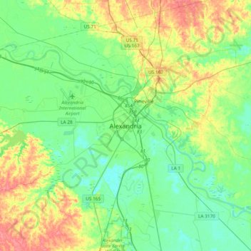
Name: Alexandria topographic map, elevation, terrain.
Location: Alexandria, Rapides Parish, Louisiana, 71301, United States (31.13098 -92.62163 31.45098 -92.30163)
Average elevation: 105 ft
Minimum elevation: 36 ft
Maximum elevation: 246 ft
Make a donation
Gear up for your next adventure:
As an Amazon Associate, this site earns from qualifying purchases at no extra cost to you.