
Make a donation
Gear up for your next adventure:
As an Amazon Associate, this site earns from qualifying purchases at no extra cost to you.
Jefferson topographic map
Click on the map to display elevation.
Make a donation
Gear up for your next adventure:
As an Amazon Associate, this site earns from qualifying purchases at no extra cost to you.
About this map
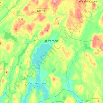
Name: Jefferson topographic map, elevation, terrain.
Location: Jefferson, Lincoln County, Maine, 04348, United States (44.10102 -69.59175 44.27546 -69.40363)
Average elevation: 197 ft
Minimum elevation: 30 ft
Maximum elevation: 525 ft
Lincoln County trails, hiking, mountain biking, running and outdoor activities
Make a donation
Gear up for your next adventure:
As an Amazon Associate, this site earns from qualifying purchases at no extra cost to you.
Other topographic maps
Click on a map to view its topography, its elevation and its terrain.
West Boothbay Harbor
United States > Maine > Lincoln County > Boothbay Harbor
Average elevation: 33 ft
Make a donation
Gear up for your next adventure:
As an Amazon Associate, this site earns from qualifying purchases at no extra cost to you.
Monhegan Island
United States > Maine > Lincoln County > Monhegan Island Plantation > Monhegan
Average elevation: 16 ft
Make a donation
Gear up for your next adventure:
As an Amazon Associate, this site earns from qualifying purchases at no extra cost to you.