
Make a donation
Gear up for your next adventure:
As an Amazon Associate, this site earns from qualifying purchases at no extra cost to you.
Klausdorf topographic map
Click on the map to display elevation.
Make a donation
Gear up for your next adventure:
As an Amazon Associate, this site earns from qualifying purchases at no extra cost to you.
Klausdorf
Nachdem sich Klausdorf bereits zu Zeiten der DDR zu einem Naherholungszentrum und Bungalow- und Villenstandort entwickelt hatte, wird nun das touristische Angebot in der Gemeinde ausgebaut. Besonders die Freibäder in Klausdorf, Sperenberg und Mellensee sind Anziehungspunkte für Besucher. Die 63 Meter lange Wasserrutsche im Freibad in Klausdorf ist eine besondere Attraktion für Kinder und Jugendliche. Die Gastronomie hat mit regionalen Spezialitäten ein beachtliches Niveau. Im Sommer besteht die Möglichkeit, Boote und Jachten zu mieten. Als Höhepunkt findet eine Lichterfahrt mit beleuchteten Booten auf dem Mellensee statt.
Make a donation
Gear up for your next adventure:
As an Amazon Associate, this site earns from qualifying purchases at no extra cost to you.
About this map
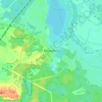
Name: Klausdorf topographic map, elevation, terrain.
Average elevation: 151 ft
Minimum elevation: 108 ft
Maximum elevation: 262 ft
Make a donation
Gear up for your next adventure:
As an Amazon Associate, this site earns from qualifying purchases at no extra cost to you.