Geolocate

Onancock topographic map

Click on the map to display elevation.

Onancock

It lies at an elevation of 16 feet, and is on the Eastern Shore of Virginia.

Wikipedia (CC-BY-SA 3.0)

About this map

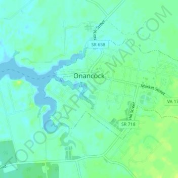
Name: Onancock topographic map, elevation, terrain.

Location: Onancock, Accomack County, Virginia, United States (37.70210 -75.75787 37.71736 -75.72778)

Average elevation: 20 ft

Minimum elevation: -10 ft

Maximum elevation: 46 ft

Accomack County trails, hiking, mountain biking, running and outdoor activities

Other topographic maps

Click on a map to view its topography, its elevation and its terrain.

Hacksneck

United States > Virginia > Accomack County

Average elevation: 3 ft

Saxis Island

United States > Virginia > Accomack County > Saxis

Average elevation: 7 ft

The Notch

United States > Virginia > Accomack County

Average elevation: 7 ft

Oak Hall

United States > Virginia > Accomack County

It lies at an elevation of 26 feet.

Average elevation: 33 ft

Deep Creek

United States > Virginia > Accomack County

Average elevation: 3 ft

Deep Creek

United States > Virginia > Accomack County

It lies at an elevation of 3 feet.

Average elevation: 3 ft

Upper Tump

United States > Virginia > Accomack County

Average elevation: 0 ft

Gear up for your next adventure:

🪶Camp Gear Gift Set - Perfect gift bundle for outdoor fans
👟Men's Trail Runners - Lightweight footwear for fast-paced exploration and light hiking
Backpacking Tents - Weight-optimized shelters for multi-day topographic surveys
🥘Titanium Cookware - Durable, featherlight pots and pans for backpacking
🥤Water Filter Bottle - All‑in‑one filter bottle for safe hydration

As an Amazon Associate, this site earns from qualifying purchases at no extra cost to you.