
Make a donation
Gear up for your next adventure:
As an Amazon Associate, this site earns from qualifying purchases at no extra cost to you.
Assawoman Island topographic map
Click on the map to display elevation.
Make a donation
Gear up for your next adventure:
As an Amazon Associate, this site earns from qualifying purchases at no extra cost to you.
About this map
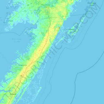
Name: Assawoman Island topographic map, elevation, terrain.
Location: Assawoman Island, Accomack County, Virginia, United States (37.47179 -75.83909 38.11179 -75.19909)
Average elevation: 7 ft
Minimum elevation: -16 ft
Maximum elevation: 75 ft
Make a donation
Gear up for your next adventure:
As an Amazon Associate, this site earns from qualifying purchases at no extra cost to you.
Other topographic maps
Click on a map to view its topography, its elevation and its terrain.
Chincoteague
United States > Virginia > Accomack County
Chincoteague is located at 37°56′5″N 75°22′4″W / 37.93472°N 75.36778°W / 37.93472; -75.36778 (37.934673, −75.367805). According to the United States Census Bureau, the town has a total area of 37.3 square miles (96.7 km2), of which 9.1 square miles (23.6 km2) is land and 28.2 square…
Average elevation: 3 ft
Make a donation
Gear up for your next adventure:
As an Amazon Associate, this site earns from qualifying purchases at no extra cost to you.
Onancock
United States > Virginia > Accomack County
It lies at an elevation of 16 feet, and is on the Eastern Shore of Virginia.
Average elevation: 20 ft
Make a donation
Gear up for your next adventure:
As an Amazon Associate, this site earns from qualifying purchases at no extra cost to you.
Onley
United States > Virginia > Accomack County
It lies at an elevation of 43 feet.
Average elevation: 46 ft
Onancock
United States > Virginia > Accomack County
It lies at an elevation of 16 feet.
Average elevation: 20 ft
Make a donation
Gear up for your next adventure:
As an Amazon Associate, this site earns from qualifying purchases at no extra cost to you.