
Xiaodian District topographic map
Interactive map
Click on the map to display elevation.
About this map
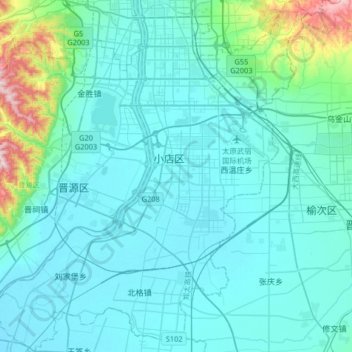
Name: Xiaodian District topographic map, elevation, terrain.
Location: Xiaodian District, Taiyuan City, Shanxi, China (37.59288 112.39456 37.85090 112.68734)
Average elevation: 2,710 ft
Minimum elevation: 2,500 ft
Maximum elevation: 4,423 ft
Other topographic maps
Click on a map to view its topography, its elevation and its terrain.
Xiwenzhuang
China > Shanxi > Taiyuan City
Xiwenzhuang, Xiaodian District, Taiyuan City, Shanxi, China
Average elevation: 2,552 ft