
Make a donation
Gear up for your next adventure:
As an Amazon Associate, this site earns from qualifying purchases at no extra cost to you.
Ponca City topographic map
Click on the map to display elevation.
Make a donation
Gear up for your next adventure:
As an Amazon Associate, this site earns from qualifying purchases at no extra cost to you.
About this map
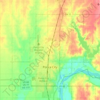
Name: Ponca City topographic map, elevation, terrain.
Location: Ponca City, Kay County, Oklahoma, 74601, United States (36.67357 -97.14123 36.77457 -96.99058)
Average elevation: 1,010 ft
Minimum elevation: 899 ft
Maximum elevation: 1,145 ft
Kay County trails, hiking, mountain biking, running and outdoor activities
Make a donation
Gear up for your next adventure:
As an Amazon Associate, this site earns from qualifying purchases at no extra cost to you.
Other topographic maps
Click on a map to view its topography, its elevation and its terrain.
West Lake Ponca;East Lake Ponca
United States > Oklahoma > Kay County > Ponca City
Average elevation: 1,040 ft