
Make a donation
Gear up for your next adventure:
As an Amazon Associate, this site earns from qualifying purchases at no extra cost to you.
Friendship topographic map
Click on the map to display elevation.
Make a donation
Gear up for your next adventure:
As an Amazon Associate, this site earns from qualifying purchases at no extra cost to you.
About this map
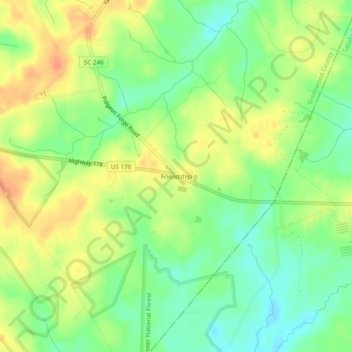
Name: Friendship topographic map, elevation, terrain.
Location: Friendship, Greenwood County, South Carolina, United States (34.02207 -81.97956 34.06207 -81.93956)
Average elevation: 548 ft
Minimum elevation: 476 ft
Maximum elevation: 620 ft
Greenwood County trails, hiking, mountain biking, running and outdoor activities
Make a donation
Gear up for your next adventure:
As an Amazon Associate, this site earns from qualifying purchases at no extra cost to you.
Other topographic maps
Click on a map to view its topography, its elevation and its terrain.
Make a donation
Gear up for your next adventure:
As an Amazon Associate, this site earns from qualifying purchases at no extra cost to you.
Promised Land
United States > South Carolina > Greenwood County > Promised Land
Average elevation: 581 ft
Ninety Six National Historic Site
United States > South Carolina > Greenwood County
Average elevation: 472 ft