Geolocate

Pine Point topographic map

Click on the map to display elevation.

About this map

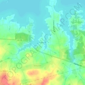
Name: Pine Point topographic map, elevation, terrain.

Location: Pine Point, Lexington County, South Carolina, United States (33.99126 -81.37343 34.03126 -81.33343)

Average elevation: 407 ft

Minimum elevation: 348 ft

Maximum elevation: 541 ft

Lexington County trails, hiking, mountain biking, running and outdoor activities

Gear up for your next adventure:

🕶️Glacier Sunglasses - Side shields to protect eyes from high-altitude snow glare
🏫Relief Map Kits - Hands-on tools for teaching landforms and elevation
🧭Map Reading Tools - Tools and kits for map navigation
🔦LED Headlamp - Bright and durable LED headlamp for night navigation
🪓Survival Multi‑Tool - Versatile tool for camp and trail tasks

As an Amazon Associate, this site earns from qualifying purchases at no extra cost to you.