
Make a donation
Gear up for your next adventure:
As an Amazon Associate, this site earns from qualifying purchases at no extra cost to you.
Paccot topographic map
Click on the map to display elevation.
Make a donation
Gear up for your next adventure:
As an Amazon Associate, this site earns from qualifying purchases at no extra cost to you.
About this map
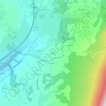
Name: Paccot topographic map, elevation, terrain.
Average elevation: 2,165 ft
Minimum elevation: 1,430 ft
Maximum elevation: 4,551 ft
Make a donation
Gear up for your next adventure:
As an Amazon Associate, this site earns from qualifying purchases at no extra cost to you.
Other topographic maps
Click on a map to view its topography, its elevation and its terrain.
Annecy-le-Vieux
France > Auvergne-Rhône-Alpes > Haute-Savoie > Annecy
La commune est située sur les premiers contreforts du mont Veyrier (1 291 m), sur un site de collines s’étendant entre 448 et 1 160 m d’altitude, en fait une ancienne langue morainique à la jonction de deux anciens grands glaciers. Elle borde le lac d'Annecy sur 1 700 m au sud et l’imposant torrent du…
Average elevation: 1,745 ft
Meythet
France > Auvergne-Rhône-Alpes > Haute-Savoie > Annecy
Le climat y est de type montagnard en raison de la présence du Semnoz, du mont Veyrier, mais également des Bauges et des Bornes. Cependant, les effets y sont quelque peu atténués en raison de la présence du lac qui tempère localement le bassin annécien, bien que les hivers restent froids en raison de…
Average elevation: 1,467 ft
Cran-Gevrier
France > Auvergne-Rhône-Alpes > Haute-Savoie > Annecy
La superficie de la commune est de 480 hectares, elle est située à 477 mètres d'altitude.
Average elevation: 1,526 ft
Seynod
France > Auvergne-Rhône-Alpes > Haute-Savoie > Annecy
L'ancienne commune de Seynod est située dans la périphérie sud-ouest d'Annecy. Son point le plus bas est le quartier de Croix-Rouge, à 450 mètres d'altitude, et son point le plus haut le Semnoz, culminant à 1 620 mètres. Son territoire s'étale le long de la route départementale 5 (D 5), de la route…
Average elevation: 2,136 ft
Make a donation
Gear up for your next adventure:
As an Amazon Associate, this site earns from qualifying purchases at no extra cost to you.
74600
France > Auvergne-Rhône-Alpes > Haute-Savoie > Annecy > Seynod > Mathonex
Average elevation: 2,215 ft
Château d'Annecy
France > Auvergne-Rhône-Alpes > Haute-Savoie > Annecy > Les Balmettes
Le château d'Annecy est situé dans le département français de la Haute-Savoie sur la commune d'Annecy, sur le dernier promontoire rocheux de la montagne du Semnoz, formant éperon, qui domine la ville au sud, à 470 mètres d'altitude. Il surveillait la route reliant Genève à l'Italie, au débouché de…
Average elevation: 1,539 ft
Cran-Gevrier
France > Auvergne-Rhône-Alpes > Haute-Savoie > Annecy
La superficie de la commune est de 480 hectares, elle est située à 477 mètres d'altitude.
Average elevation: 1,526 ft
Make a donation
Gear up for your next adventure:
As an Amazon Associate, this site earns from qualifying purchases at no extra cost to you.
Cran-Gevrier
France > Auvergne-Rhône-Alpes > Haute-Savoie > Annecy
La superficie de la commune est de 480 hectares, elle est située à 477 mètres d'altitude.
Average elevation: 1,526 ft