
Parma topographic map
Click on the map to display elevation.
About this map
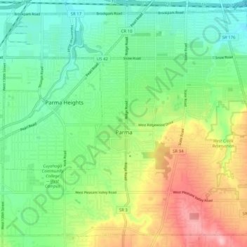
Name: Parma topographic map, elevation, terrain.
Location: Parma, Cuyahoga County, Ohio, United States (41.35038 -81.78506 41.41941 -81.68451)
Average elevation: 925 ft
Minimum elevation: 741 ft
Maximum elevation: 1,260 ft
Cuyahoga County trails, hiking, mountain biking, running and outdoor activities
Other topographic maps
Click on a map to view its topography, its elevation and its terrain.
Cuyahoga Valley National Park
United States > Ohio > Cuyahoga County > Independence
Average elevation: 686 ft
Cleveland
United States > Ohio > Cuyahoga County > Cleveland
The land rises quickly from the lake shore elevation of 569 feet. Public Square, less than one mile (1.6 km) inland, sits at an elevation of 650 feet (198 m), and Hopkins Airport, 5 miles (8 km) inland from the lake, is at an elevation of 791 feet (241 m).
Average elevation: 719 ft