Geolocate

Apapa topographic map

Click on the map to display elevation.

About this map

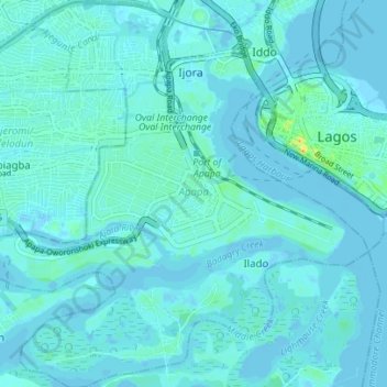
Name: Apapa topographic map, elevation, terrain.

Location: Apapa, Lagos State, Nigeria (6.41007 3.33134 6.47925 3.39988)

Average elevation: 10 ft

Minimum elevation: -16 ft

Maximum elevation: 98 ft

Other topographic maps

Click on a map to view its topography, its elevation and its terrain.

Tincan Island

Nigeria > Lagos State > Apapa

Average elevation: 10 ft

Gear up for your next adventure:

🛏️Cold Weather Sleeping Bag - Warm sleeping bag for cold conditions
🌄Hiking Binoculars - Compact binoculars for scenic views and trail spotting
🌲Outdoor Survival Books - Best books on survival skills
🎒Outdoor Daypacks - Lightweight backpacks designed for carrying maps and essential gear
🧤Tactile Hiking Gloves - Keep hands warm while operating GPS and smartphone screens

As an Amazon Associate, this site earns from qualifying purchases at no extra cost to you.