Geolocate

Magadi topographic map

Click on the map to display elevation.

Magadi

Magadi is located at 12°58′N 77°14′E / 12.97°N 77.23°E / 12.97; 77.23. It has an average elevation of 925 metres (3034 feet).

About this map

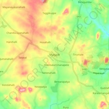
Name: Magadi topographic map, elevation, terrain.

Location: Magadi, Magadi taluku, Ramanagara district, Karnataka, 562120, India (12.91674 77.18423 12.99674 77.26423)

Average elevation: 2,861 ft

Minimum elevation: 2,575 ft

Maximum elevation: 3,189 ft

Gear up for your next adventure:

🔋Rechargeable Batteries - Power up your outdoor devices
🛡️Insect Repellent - Protection against bugs during outdoor activities
🥤Water Filter Bottle - All‑in‑one filter bottle for safe hydration
🔊Portable Camp Speaker - Music and alerts at camp
🪶Compact Camp Shovel - Folding shovel for campsite tasks

As an Amazon Associate, this site earns from qualifying purchases at no extra cost to you.