Geolocate

Basel topographic map

Click on the map to display elevation.

About this map

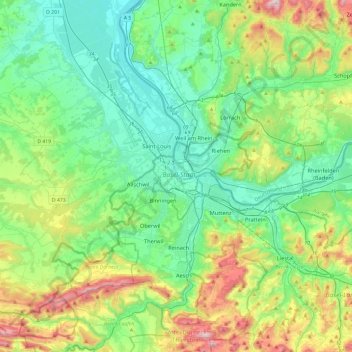
Name: Basel topographic map, elevation, terrain.

Location: Basel, Basel-City, 4001, Switzerland (47.39811 7.42783 47.71811 7.74783)

Average elevation: 1,325 ft

Minimum elevation: 709 ft

Maximum elevation: 3,054 ft

Gear up for your next adventure:

🛰️Handheld GPS Units - Professional satellite navigators for precise backcountry mapping
🪶Camp Gear Gift Set - Perfect gift bundle for outdoor fans
🎒Gear Packing Cubes - Organize your backpack efficiently
🗺️Topographic Maps - Detailed topo maps for hiking, exploring and outdoor navigation
🛌Ultralight Sleeping Bags - Compact down bags for cold nights in the wilderness

As an Amazon Associate, this site earns from qualifying purchases at no extra cost to you.