Geolocate

Dierks topographic map

Click on the map to display elevation.

About this map

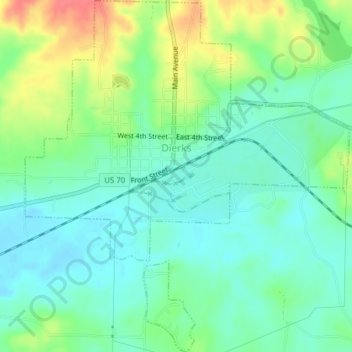
Name: Dierks topographic map, elevation, terrain.

Location: Dierks, Howard County, Arkansas, United States (34.10062 -94.03327 34.13271 -93.99754)

Average elevation: 456 ft

Minimum elevation: 390 ft

Maximum elevation: 587 ft

Howard County trails, hiking, mountain biking, running and outdoor activities

Other topographic maps

Click on a map to view its topography, its elevation and its terrain.

Perkins

United States > Arkansas > Howard County

Average elevation: 525 ft

Big Tom Mountain

United States > Arkansas > Howard County

Average elevation: 1,240 ft

Briar

United States > Arkansas > Howard County

Average elevation: 499 ft

Big Tom Mountain

United States > Arkansas > Howard County

Average elevation: 1,240 ft

Gear up for your next adventure:

📷Action Camera - Capture your outdoor adventures in HD
👓Polarized Sunglasses - Outdoor sunglasses for glare reduction
🪶Camp Gear Gift Set - Perfect gift bundle for outdoor fans
🔥Fast-Boil Camping Stoves - Efficient cooking systems for quick trail meals
🧯Portable Fire Pit - Compact fire pit for camping spots

As an Amazon Associate, this site earns from qualifying purchases at no extra cost to you.