
Make a donation
Gear up for your next adventure:
As an Amazon Associate, this site earns from qualifying purchases at no extra cost to you.
Wörth an der Isar topographic map
Click on the map to display elevation.
Make a donation
Gear up for your next adventure:
As an Amazon Associate, this site earns from qualifying purchases at no extra cost to you.
Wörth an der Isar
In Folge einer entsprechenden Bewertung ihrer Wirtschaftskraft wurden der Gemeinde Wörth in den Jahren 2015 bis 2018 vom Freistaat Bayern keine Schlüsselzuweisungen zugeteilt. Im Jahr 2019 erfolgte schließlich eine Zahlung in Höhe von 139.392 Euro. Für das Jahr 2020 gab es dann erneut keine Zuteilung.
Make a donation
Gear up for your next adventure:
As an Amazon Associate, this site earns from qualifying purchases at no extra cost to you.
About this map
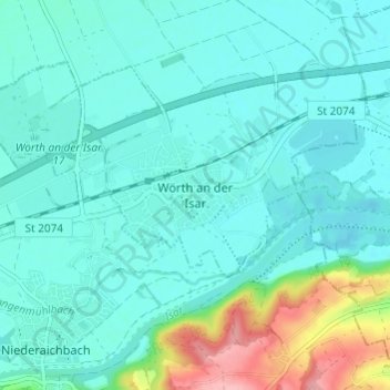
Name: Wörth an der Isar topographic map, elevation, terrain.
Average elevation: 1,257 ft
Minimum elevation: 1,181 ft
Maximum elevation: 1,585 ft
Make a donation
Gear up for your next adventure:
As an Amazon Associate, this site earns from qualifying purchases at no extra cost to you.