Geolocate

Payao topographic map

Click on the map to display elevation.

About this map

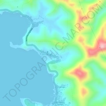
Name: Payao topographic map, elevation, terrain.

Location: Payao, Catbalogan, Samar, Eastern Visayas, 6700, Philippines (11.80057 124.85407 11.80662 124.86962)

Average elevation: 161 ft

Minimum elevation: -7 ft

Maximum elevation: 728 ft

Other topographic maps

Click on a map to view its topography, its elevation and its terrain.

Timmys Little Bagiou

Philippines > Samar > Catbalogan > Canlapwas

Average elevation: 207 ft

Brgy 12

Philippines > Samar > Catbalogan

Average elevation: 161 ft

Tagbayaon

Philippines > Samar > Catbalogan

Average elevation: 348 ft

San Roque

Philippines > Samar > Catbalogan

Average elevation: 26 ft

Cagutian

Philippines > Samar > Catbalogan

Average elevation: 361 ft

Lagundi

Philippines > Samar > Catbalogan

Average elevation: 213 ft

Antiao River

Philippines > Samar > Catbalogan > Maulong

Average elevation: 456 ft

Maulong

Philippines > Samar > Catbalogan

Average elevation: 112 ft

Tagbayaon

Philippines > Samar > Catbalogan

Average elevation: 348 ft

Kruse Island

Philippines > Samar > Catbalogan

Average elevation: 135 ft

Tagbayaon

Philippines > Samar > Catbalogan

Average elevation: 348 ft

Gear up for your next adventure:

🦟Ultrasonic Repellers - Create a bug-free zone at your camp or rest stop
🗺️NatGeo Topo Maps - High-quality waterproof printed topographic maps of US Parks
🛏️Cold Weather Sleeping Bag - Warm sleeping bag for cold conditions
📚USA Hiking Guide Books - Top trail guides and map books
🪶Survival Guide Book - Expert advice for emergency preparedness

As an Amazon Associate, this site earns from qualifying purchases at no extra cost to you.