
Thank you for supporting this site ❤️
Make a donation
Make a donation
Gear up for your next adventure:
As an Amazon Associate, this site earns from qualifying purchases at no extra cost to you.
Gomez-Zamora topographic map
Click on the map to display elevation.
Thank you for supporting this site ❤️
Make a donation
Make a donation
Gear up for your next adventure:
As an Amazon Associate, this site earns from qualifying purchases at no extra cost to you.
About this map
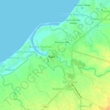
Name: Gomez-Zamora topographic map, elevation, terrain.
Location: Gomez-Zamora, Naic, Cavite, Calabarzon, 4110, Philippines (14.29998 120.74529 14.33998 120.78529)
Average elevation: 39 ft
Minimum elevation: 0 ft
Maximum elevation: 105 ft
Thank you for supporting this site ❤️
Make a donation
Make a donation
Gear up for your next adventure:
As an Amazon Associate, this site earns from qualifying purchases at no extra cost to you.
Other topographic maps
Click on a map to view its topography, its elevation and its terrain.