
Thank you for supporting this site ❤️
Make a donation
Make a donation
Gear up for your next adventure:
As an Amazon Associate, this site earns from qualifying purchases at no extra cost to you.
Talkhamt topographic map
Click on the map to display elevation.
Thank you for supporting this site ❤️
Make a donation
Make a donation
Gear up for your next adventure:
As an Amazon Associate, this site earns from qualifying purchases at no extra cost to you.
About this map
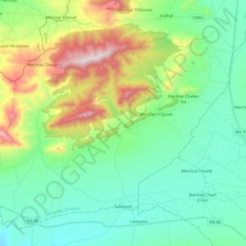
Name: Talkhamt topographic map, elevation, terrain.
Location: Talkhamt, Daïra de Ras El Aioun, Batna, Algérie (35.65191 5.67833 35.79447 5.88128)
Average elevation: 3,478 ft
Minimum elevation: 2,648 ft
Maximum elevation: 5,689 ft
Thank you for supporting this site ❤️
Make a donation
Make a donation
Gear up for your next adventure:
As an Amazon Associate, this site earns from qualifying purchases at no extra cost to you.
Other topographic maps
Click on a map to view its topography, its elevation and its terrain.