
Sumra topographic map
Interactive map
Click on the map to display elevation.
About this map
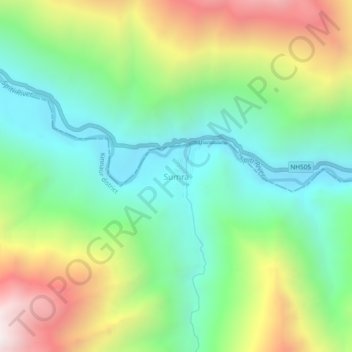
Name: Sumra topographic map, elevation, terrain.
Location: Sumra, Hangrang, Kinnaur district, Himachal Pradesh, India (32.02884 78.47047 32.06884 78.51047)
Average elevation: 11,926 ft
Minimum elevation: 10,253 ft
Maximum elevation: 14,948 ft
Other topographic maps
Click on a map to view its topography, its elevation and its terrain.
Kuno
India > Himachal Pradesh > Kinnaur district
Kuno, Moorang, Kinnaur district, Himachal Pradesh, India
Average elevation: 13,143 ft
Ribba
India > Himachal Pradesh > Kinnaur district
Ribba, Moorang, Kinnaur district, Himachal Pradesh, 172116, India
Average elevation: 8,766 ft
Pooh
India > Himachal Pradesh > Kinnaur district
Pooh, Poo district, Kinnaur district, Himachal Pradesh, 172111, India
Average elevation: 10,062 ft
Nako
India > Himachal Pradesh > Kinnaur district > Nako
Nako, Poo district, Kinnaur district, Himachal Pradesh, India
Average elevation: 11,837 ft
Poo district
India > Himachal Pradesh > Kinnaur district
Poo district, Kinnaur district, Himachal Pradesh, India
Average elevation: 14,347 ft