
Make a donation
Gear up for your next adventure:
As an Amazon Associate, this site earns from qualifying purchases at no extra cost to you.
Klotzsche topographic map
Click on the map to display elevation.
Make a donation
Gear up for your next adventure:
As an Amazon Associate, this site earns from qualifying purchases at no extra cost to you.
About this map
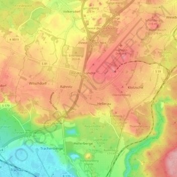
Name: Klotzsche topographic map, elevation, terrain.
Location: Klotzsche, Dresden, Sachsen, 01109, Deutschland (51.08978 13.70275 51.14659 13.80754)
Average elevation: 620 ft
Minimum elevation: 358 ft
Maximum elevation: 827 ft
Make a donation
Gear up for your next adventure:
As an Amazon Associate, this site earns from qualifying purchases at no extra cost to you.
Other topographic maps
Click on a map to view its topography, its elevation and its terrain.
Dresden
Deutschland > Sachsen > Dresden
Als Höhenreferenz für Dresden gilt der Altmarkt als zentraler Platz der Stadt mit einer Höhe von 113 m ü. NN, der Nullpunkt des Elbpegels liegt bei 102,73 m. Die höchste Erhebung im Stadtgebiet ist der rechts der Elbe gelegene 383 m hohe Triebenberg, der tiefste Punkt liegt am Elbufer in Niederwartha mit 101 m.
Average elevation: 778 ft
Make a donation
Gear up for your next adventure:
As an Amazon Associate, this site earns from qualifying purchases at no extra cost to you.
Merbitz
Deutschland > Sachsen > Dresden
Die südöstliche Flurgrenze des Ortsteils zu Ockerwitz und Omsewitz verläuft im Zschonergrund. Hier liegt zugleich mit 160 m ü. NN die tiefste Stelle der Gemarkung. Über die Merbitzer Flur verläuft in einem knapp 1 km langen Abschnitt östlich des Autobahndreiecks Dresden-West die A 4. Sie passiert den…
Average elevation: 633 ft