
Montaña del Cardón topographic map
Interactive map
Click on the map to display elevation.
About this map
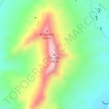
Name: Montaña del Cardón topographic map, elevation, terrain.
Location: Montaña del Cardón, Pájara, Las Palmas, Canarias, España (28.25697 -14.15818 28.25707 -14.15808)
Average elevation: 1,178 ft
Minimum elevation: 551 ft
Maximum elevation: 2,257 ft
Other topographic maps
Click on a map to view its topography, its elevation and its terrain.
Playa Del Matorral
Playa Del Matorral, Calle El Hierro, Esquinzo, Pájara, Las Palmas, Canarias, 35626, España
Average elevation: 249 ft
Península de Jandía
Península de Jandía, GR 131 / SL FV11 Barranco de Pecenescal, Casas del Valluelo, Pájara, Las Palmas, Canarias, España
Average elevation: 141 ft