
Península de Jandía topographic map
Interactive map
Click on the map to display elevation.
About this map
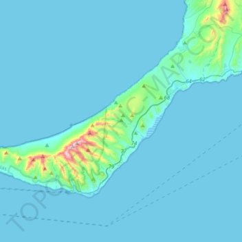
Name: Península de Jandía topographic map, elevation, terrain.
Average elevation: 141 ft
Minimum elevation: -7 ft
Maximum elevation: 2,585 ft
Other topographic maps
Click on a map to view its topography, its elevation and its terrain.
Playa Del Matorral
Playa Del Matorral, Calle El Hierro, Esquinzo, Pájara, Las Palmas, Canarias, 35626, España
Average elevation: 249 ft
Montaña del Cardón
Montaña del Cardón, Pájara, Las Palmas, Canarias, España
Average elevation: 1,178 ft