
Gurdaspur topographic map
Interactive map
Click on the map to display elevation.
About this map
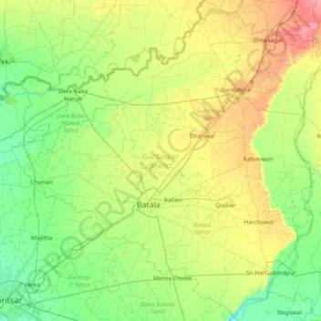
Name: Gurdaspur topographic map, elevation, terrain.
Location: Gurdaspur, Punjab, India (31.59387 74.88848 32.21387 75.60134)
Average elevation: 810 ft
Minimum elevation: 738 ft
Maximum elevation: 965 ft
All the Tehsils of the district namely Gurdaspur, Batala and Dera Baba Nanak are plain and similar to the rest of the Punjab plains in structure. The landscape of the district has varied topography comprising undulating plan, the flood plains of the Ravi and the Beas and the upland plain.
Other topographic maps
Click on a map to view its topography, its elevation and its terrain.