Geolocate

La Union topographic map

Click on the map to display elevation.

About this map

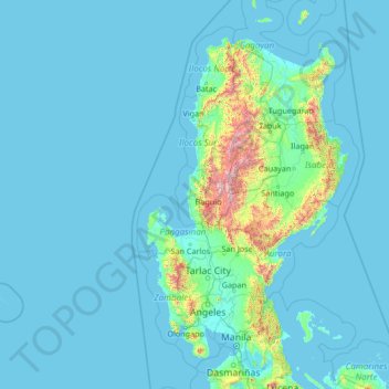
Name: La Union topographic map, elevation, terrain.

Location: La Union, Ilocos Region, Philippines (14.01360 117.84899 19.13360 122.96899)

Average elevation: 354 ft

Minimum elevation: 0 ft

Maximum elevation: 9,272 ft

Other topographic maps

Click on a map to view its topography, its elevation and its terrain.

Sudipen

Philippines > La Union

Average elevation: 315 ft

Caba

Philippines > La Union

Average elevation: 200 ft

Santo Tomas

Philippines > La Union

Average elevation: 194 ft

Gear up for your next adventure:

🦶Carbon Trekking Poles - Reduce knee impact on steep descents with ultra-light poles
🪵Folding Camp Saw - Compact saw for wood and campsite work
🛠️Outdoor Gear Repair Kit - Essential tools to fix gear on the trail
🧭Orienteering Set - Complete compass and map reading kit
🪑Portable Camp Table - Compact table for campsite meals

As an Amazon Associate, this site earns from qualifying purchases at no extra cost to you.