Geolocate

Wrose topographic map

Click on the map to display elevation.

About this map

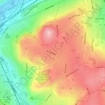
Name: Wrose topographic map, elevation, terrain.

Location: Wrose, Bradford, West Yorkshire, England, United Kingdom (53.81981 -1.76560 53.83449 -1.73357)

Average elevation: 499 ft

Minimum elevation: 210 ft

Maximum elevation: 738 ft

Other topographic maps

Click on a map to view its topography, its elevation and its terrain.

Wrose

United Kingdom > England > Bradford > Wrose

Average elevation: 446 ft

Gear up for your next adventure:

🦟Ultrasonic Repellers - Create a bug-free zone at your camp or rest stop
👟Trail Running Shoes - Lightweight shoes for trail runners
🔭Compact Binoculars - HD vision for scouting terrain and identifying distant landmarks
🧯Portable Fire Pit - Compact fire pit for camping spots
🪄Magnetic Compass - Accurate compass for navigation

As an Amazon Associate, this site earns from qualifying purchases at no extra cost to you.