
Lerma topographic map
Interactive map
Click on the map to display elevation.
About this map
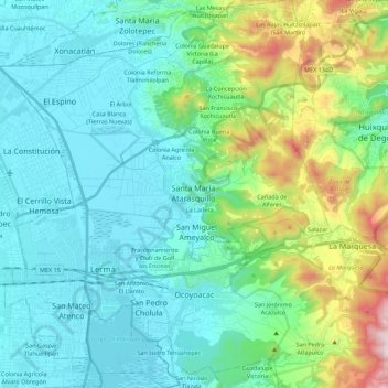
Name: Lerma topographic map, elevation, terrain.
Location: Lerma, État de Mexico, Mexique (19.22195 -99.57198 19.43067 -99.38191)
Average elevation: 9,147 ft
Minimum elevation: 8,386 ft
Maximum elevation: 12,077 ft
Other topographic maps
Click on a map to view its topography, its elevation and its terrain.
Fraccionamiento Las Golondrinas
Mexique > État de Mexico > Lerma
Fraccionamiento Las Golondrinas, Lerma, État de Mexico, 52004, Mexique
Average elevation: 8,451 ft
Lerma de Villada
Mexique > État de Mexico > Lerma
Lerma de Villada, Lerma, État de Mexico, 52006, Mexique
Average elevation: 8,455 ft